The Details
Better links between the railway station and the town centre could ultimately lead to a connection to the NCN 7 along the Whitesands helping to drive cycle tourism business into the centre of town and making it easier for business visitors and students to reach the DGRI, The Bridge and The Crichton. Some work has been done towards this end, but there is still no continuous link between the station and the town centre itself, let alone to the Whitesands. Given the station is just over 500m from Queensberry Square, this is a priority Missing Link.
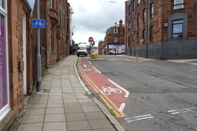
Newall Terrace has been partially developed as part of this route. At the town centre end of this road there is a short length of eastbound one-way road with a contraflow cycle lane which means it is quiet enough for on-road cycling. However, the lane itself is regularly obstructed by parked motor vehicles, despite the presence of waiting restrictions. This forces cyclists into oncoming traffic that is anticipating a one-way street.

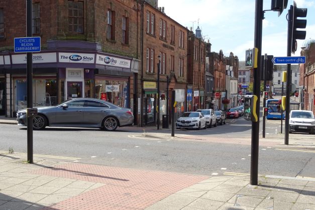
Heading towards the town centre, there is a controlled crossing on Loreburn Street between Newall Terrace and Great King Street, including for cycles. This works well for cyclists heading to the railway station from Great King Street. However, cyclists heading to the town centre have to turn left along the multi-lane Loreburn Street then right into Munches Street. Local residents familiar with the route may cope with this, however, for visitors it must be confusing as you have to cross the lanes immediately and there is no indication that Munches Street does lead to the centre of town. If they miss this turn they would be forced down English Street away from the town centre.
Cyclists with a green light at the crossing are put in conflict with vehicles turning right from Great King Street. Whilst there is a 1 or 2 second delay before these vehicles get a green light, and they have to travel a short distance to get to Loreburn Street, they are then in conflict with any cyclists from Newall Terrace who arrive at the junction with the green light. Neither cyclists nor drivers would expect this which is concerning.

One solution would be to stagger the green lights, although this would either mean a shorter green time for crossing or longer waits for traffic on Loreburn Street. The ideal solution would be to make Great King Street two-way for bikes while still one-way for cars (without a contraflow lane). This avoids the need for cyclists to tackle Loreburn Street at all. The bigger issue with this route to and from the station is the need to cross Lover’s Walk to get between Newall Terrace and the station. Lover’s Walk is part of the temporary 20mph speed limit, but this is a busy road and a bus route. Heading towards the station, at the Newall Terrace/Lover’s Walk junction there is adequate visibility to the left, but very restricted visibility to the right. Some cyclists prefer to divert along Rae Street to make the turn easier. The crossing is no easier for pedestrians or users of mobility scooters especially if the pedestrians have limited mobility or are hard of hearing. There is reasonable visibility in both directions when coming from the station, but it still feels a leap of faith when coming out of the forecourt entrance on to the main road. The width of the road and footway corridor between these two junctions is limited. Putting in a controlled crossing for both bikes and pedestrians would require a stretch of shared path and hence wider footways, and it is hard to see how this could be done without acquiring land from adjacent properties. However, some form of solution is required if the council is serious about prioritising active travel and creating a continuous, usable and safe walking, wheeling and cycle route between the railway station and the town centre. Doing so would not only connect up the station and the town centre, but also provide a continuous route on to the Caledonian and Maxwelltown paths, creating significant network effects by joining up the existing traffic-free routes. To summarise, in order of priority, this route could completed by:
- Remove the conflict between cyclists and vehicles at the Loreburn Street crossing.
- Create a safe crossing of Lover’s Walk for cyclists and pedestrians.
- Provide clear walking and cycling signs from the station to the town and vice versa.
- Make the 20mph limits on Newall Terrace (and beyond) permanent and increase repeater signs on Newall Terrace and Lover’s Walk.
- Provide “Except cycles” signs below the “No through road” signs on Newall Terrace at the Catherine Street junction.
- Make Great King Street two-way for cyclists.
The issue of the regular obstruction of the contraflow cycle lane at the end of Newall Terrace requires serious consideration. This appears to be complicated by the adjacent cellar access for the Fleshers pub, meaning the brewery dray stops there to deliver (although other vehicles also block this lane). Some possible actions and options to address this specific issue include:
- Parking enforcement.
- Changing the advisory cycle lane to a mandatory one, although this would still rely on enforcement.
- Extending the no loading/unloading restriction at the junction eastwards along the full length of the advisory lane.
- Provide intermittent kerbs and/or bollards along the edge of the advisory cycle lane to physically separate the lane from the road and to prevent parking in the lane.
- Widening the footway on the south side of Newall Terrace along the length of the current advisory lane, to allow a segregated lane.
- Provide parking on the north side of Newall Terrace immediately to the east, by removing part of the existing “No Waiting At Any Time” restriction by the Oasis Youth Centre. This would remove any excuse for the current illegal parking, whilst also slowing traffic by narrowing the effective width of the road.

